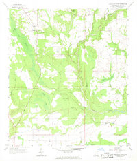
1957 Map of Dead Tiger Creek
USGS Topo · Published 1969About this map
Dead Tiger Creek and its many meandering tributaries define the low-lying wetland topography of this Hancock County landscape during the late 1950s. The drainage pattern is exceptionally intricate, characterized by numerous "bays"—shallow, swampy depressions such as Sam Farve Bay, Double Bay, and Adgreen Bay. These features suggest a terrain dominated by slow-moving water and dense bottomland vegetation, where human settlement was sparse and largely confined to slightly higher ground near the northern margins.
Find a feature on this map
24 named features on this map. Tap any name to fly to it.
Don’t see what you’re looking for? This feature index may not catch every label — zoom into the map to look around manually.
Map Details
Editions of this 1957 Dead Tiger Creek Map
4 editions found

Other maps of this area

1914 · Nicholson
USGS Topo · 1:62,500

1921 · Nicholson
USGS Topo · 1:62,500

1941 · Honey Island
USGS Topo · 1:31,680

1950 · Haaswood
USGS Topo · 1:31,680

1953 · Mobile
USGS Topo · 1:250,000

1954 · Haaswood
USGS Topo · 1:31,680

1955 · Savannah
USGS Topo · 1:62,500

1955 · Nicholson
USGS Topo · 1:24,000

1956 · Waveland
USGS Topo · 1:24,000

1957 · Mobile
USGS Topo · 1:250,000