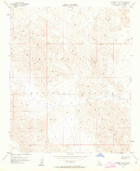
1955 Map of Deadman Lake NE
USGS Topo · Published 1963About this map
The Bullion Mountains dominate this high-desert landscape in San Bernardino County, where the topography is defined by sharp contour lines and arid peaks. This mid-century survey by the Geological Survey and the California Department of Water Resources records a transition in land use, as indicated by the presence of a Training Center designation across the central and southern portions of the sheet. The map is a study in verticality and military geography, centered on the high ground of Vabm Rough. With few roads or permanent civilian structures, the area serves as a primary example of the mid-20th-century desert ranges that were repurposed for strategic defense and training purposes, leaving much of the natural terrain undisturbed save for survey markers.
Find a feature on this map
3 named features on this map. Tap any name to fly to it.
Don’t see what you’re looking for? This feature index may not catch every label — zoom into the map to look around manually.
Map Details
Editions of this 1955 Deadman Lake NE Map
5 editions found

Other maps of this area

1942 · Amboy
USGS Topo · 1:250,000

1943 · Amboy
USGS Topo · 1:250,000

1953 · San Bernardino
USGS Topo · 1:250,000

1954 · Needles
USGS Topo · 1:250,000

1954 · Bagdad SW
USGS Topo · 1:24,000

1954 · Ludlow SE
USGS Topo · 1:24,000

1955 · Deadman Lake NW
USGS Topo · 1:24,000

1955 · Morgans Well
USGS Topo · 1:24,000

1955 · Lead Mountain
USGS Topo · 1:24,000

1955 · Deadman Lake SE
USGS Topo · 1:24,000