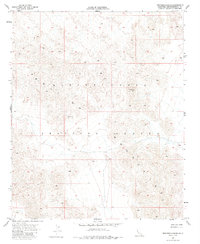
1955 Map of Deadman Lake NE
USGS Topo · Published 1985About this map
U S Marine Corps Training Center dominates this high-desert landscape in the Mojave. This 1955 field-checked survey documents a period of significant military expansion in San Bernardino County, as the U S Marine Corps Training Center was established across this arid terrain. The map details a complex network of unimproved dirt roads and trails through the mountainous desert topography, serving as a record of military land use and infrastructure before subsequent decades of development. The contour lines reveal a rugged, high-elevation environment with numerous peaks and dry washes that defined the training maneuvers and operations conducted by the Department of the Interior and the State of California Department of Water Resources during the mid-twentieth century.
Find a feature on this map
2 named features on this map. Tap any name to fly to it.
Don’t see what you’re looking for? This feature index may not catch every label — zoom into the map to look around manually.
Map Details
Editions of this 1955 Deadman Lake NE Map
5 editions found

Other maps of this area

1942 · Amboy
USGS Topo · 1:250,000

1943 · Amboy
USGS Topo · 1:250,000

1953 · San Bernardino
USGS Topo · 1:250,000

1954 · Needles
USGS Topo · 1:250,000

1954 · Bagdad SW
USGS Topo · 1:24,000

1954 · Ludlow SE
USGS Topo · 1:24,000

1955 · Deadman Lake NW
USGS Topo · 1:24,000

1955 · Morgans Well
USGS Topo · 1:24,000

1955 · Lead Mountain
USGS Topo · 1:24,000

1955 · Deadman Lake SE
USGS Topo · 1:24,000