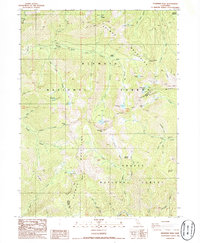
1986 Map of Deadman Peak
USGS Topo · Published 1986About this map
The Salmon Mountains divide the high-altitude landscape of Siskiyou and Trinity counties, where the headwaters of several major Northern California river systems originate. This mid-1980s survey details the remote divide between the Klamath National Forest and Shasta National Forest, a region defined by alpine lakes and meadows. The Pacific Crest National Scenic Trail traverses the ridges, passing landmarks like Carter Meadows Summit and the prominent Deadman Peak. Evidence of earlier resource extraction is noted through the tailings found along the upper reaches of Coffee Creek. The map also identifies isolated structures like the Schlomberg Cabin and numerous family-named meadows such as Joe Keen Meadows and Lees Meadow, reflecting the high-country grazing and pack-trail history of the area.
Find a feature on this map
51 named features on this map. Tap any name to fly to it.
Don’t see what you’re looking for? This feature index may not catch every label — zoom into the map to look around manually.
Map Details
Editions of this 1986 Deadman Peak Map
2 editions found
Other maps of this area

1886 · Shasta
USGS Topo · 1:250,000

1894 · Shasta
USGS Topo · 1:250,000

1923 · Sawyers Bar
USGS Topo · 1:125,000

1931 · Etna
USGS Topo · 1:96,000

1934 · Etna
USGS Topo · 1:125,000

1948 · Weed
USGS Topo · 1:250,000

1950 · Weed
USGS Topo · 1:250,000

1955 · Cecilville
USGS Topo · 1:62,500

1955 · Sawyers Bar
USGS Topo · 1:62,500

1955 · Etna
USGS Topo · 1:62,500