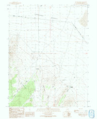
1991 Map of Deadman Point
USGS Topo · Published 1991About this map
The Burbank Hills rise sharply from the arid floor of the Ferguson Desert in this detailed survey of Millard County. The map documents a landscape defined by the search for water in a high-desert environment, where isolated features such as Hardpan Well, the Cedar Pass Reservoir, and the Deadman Reservoir represent vital infrastructure for grazing and transit. The topography is segmented by a series of drainages, including Juniper Wash, Jensen Wash, and Deadman Wash, which channel seasonal runoff away from the distinctive Red Ledges. Human activity is marked by the presence of a Corral and a Water Tank, alongside the primary artery of the Garrison Black Rock Road. The prominence of Deadman Point serves as a major landmark for navigators following the 4 WD trails that crisscross the terrain near Cedar Pass.
Find a feature on this map
19 named features on this map. Tap any name to fly to it.
Don’t see what you’re looking for? This feature index may not catch every label — zoom into the map to look around manually.
Map Details
Editions of this 1991 Deadman Point Map
This is the sole edition of this map. No revisions or reprints were ever made.
Other maps of this area

1908 · Fish Springs
USGS Topo · 1:250,000

1910 · Fish Springs
USGS Topo · 1:250,000

1953 · Richfield
USGS Topo · 1:250,000

1953 · Delta
USGS Topo · 1:250,000

1958 · Richfield
USGS Topo · 1:250,000

1958 · Delta
USGS Topo · 1:250,000

1960 · Conger Range
USGS Topo · 1:62,500

1960 · Burbank Hills
USGS Topo · 1:62,500

1960 · Crystal Peak
USGS Topo · 1:62,500

1960 · Conger Mountain
USGS Topo · 1:62,500