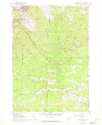
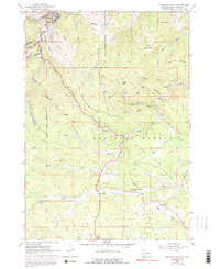
1961 Map of Deadwood South
USGS Topo · Published 1972About this map
The Black Hills landscape south of Deadwood is defined by a dense network of gulches and ridges that shaped the region's mining and transit history. In this 1961 survey, updated in 1971, the Burlington Northern railroad winds through the steep terrain between Lead and Pluma, following the contours of Whitewood Creek and Deadwood Creek. The map documents a transition from industrial activity to recreation, showing numerous Mines and Pits alongside the Strawberry Hill Campground and the Tomahawk Country Club. The geography is anchored by prominent summits like Pillar Peak, Bear Den Mountain, and Anchor Hill, which rise above the Black Hills National Forest. To the south, smaller settlements like Galena, Brownsville, and Roubaix sit along the creek beds, connected by Strawberry Ridge and Windy Flats.
Find a feature on this map
46 named features on this map. Tap any name to fly to it.
Don’t see what you’re looking for? This feature index may not catch every label — zoom into the map to look around manually.
Map Details
Editions of this 1961 Deadwood South Map
5 editions found
Other maps of this area

1894 · Deadwood
USGS Topo · 1:125,000

1899 · Sturgis
USGS Topo · 1:62,500

1900 · Spearfish
USGS Topo · 1:62,500

1901 · Deadwood
USGS Topo · 1:125,000

1915 · Spearfish
USGS Topo · 1:62,500

1915 · Sturgis
USGS Topo · 1:62,500

1916 · Deadwood
USGS Topo · 1:125,000

1953 · Nemo
USGS Topo · 1:24,000

1953 · Rapid City
USGS Topo · 1:250,000
1954 · Deadman Mountain
USGS Topo · 1:24,000