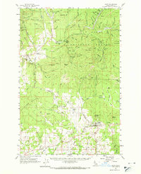
1961 Map of Deary
USGS Topo · Published 1971About this map
The Washington Idaho and Montana railroad winds through the timbered landscape of northern Latah County, connecting the small settlements of Harvard and Yale along the East Fork Potlatch River. This 1961 field-checked survey reveals an economy deeply tied to the land, with numerous extraction sites including the Gold Bug Mine, Luella Mine, and several clay and gravel pits. The rugged geography is defined by high points like Sand Mtn and Mica Mtn, while the St Joe National Forest occupies the northern reaches.
Find a feature on this map
107 named features on this map. Tap any name to fly to it.
Don’t see what you’re looking for? This feature index may not catch every label — zoom into the map to look around manually.
Map Details
Editions of this 1961 Deary Map
2 editions found
Other maps of this area

1955 · Pullman
USGS Topo · 1:250,000

1955 · Spokane
USGS Topo · 1:250,000

1957 · Emida
USGS Topo · 1:62,500

1957 · Tensed
USGS Topo · 1:62,500

1958 · Spokane
USGS Topo · 1:250,000

1958 · Pullman
USGS Topo · 1:250,000

1960 · Troy
USGS Topo · 1:24,000

1960 · Moscow Mtn
USGS Topo · 1:24,000

1960 · Potlatch
USGS Topo · 1:62,500

1961 · Deary
USGS Topo · 1:62,500