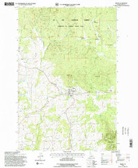
1994 Map of Deary
USGS Topo · Published 1997About this map
Deary serves as the focal point of this Latah County survey, situated at the junction of the Burlington Northern railroad and several local drainages. The landscape transitions from the developed town site, featuring sewage disposal ponds and local quarries, into the dense timber of the St Joe National Forest. Notable topographic features like Potato Hill and Cherry Butte rise above the surrounding plateaus, while Bear Ridge and Texas Ridge define the local relief. Smaller settlements like Vassar and Avon are captured alongside vital community landmarks including Zion Cem and Dry Creek Cem. The intricate network of Big Bear Creek and its many forks, such as the East Fork and West Fork, illustrates the complex hydrology of this Idaho timber and farming region during the mid-1990s.
Find a feature on this map
38 named features on this map. Tap any name to fly to it.
Don’t see what you’re looking for? This feature index may not catch every label — zoom into the map to look around manually.
Map Details
Editions of this 1994 Deary Map
This is the sole edition of this map. No revisions or reprints were ever made.
Other maps of this area

1955 · Pullman
USGS Topo · 1:250,000

1958 · Pullman
USGS Topo · 1:250,000

1961 · Deary
USGS Topo · 1:62,500

1961 · Kendrick
USGS Topo · 1:62,500

1961 · Ahsahka
USGS Topo · 1:62,500

1961 · Bovill
USGS Topo · 1:62,500

1981 · Potlatch
USGS Topo · 1:100,000
1990 · Stanford
USGS Topo · 1:24,000
1990 · Harvard
USGS Topo · 1:24,000
1990 · Texas Ridge
USGS Topo · 1:24,000