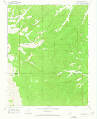
1964 Map of Death Ridge
USGS Topo · Published 1975About this map
Dixie National Forest defines the northwestern reaches of this 1964 survey, where the high terrain of Death Ridge descends into a complex network of canyons and washes. This remote section of the Colorado Plateau captures the boundary between Garfield Co and Kane Co in an era of minimal human intervention. The landscape is marked by essential water sources for livestock and wildlife, including Death Ridge Reservoir, Camp Spring, and Star Seep, which stand out against the arid canyon floors.
Find a feature on this map
18 named features on this map. Tap any name to fly to it.
Don’t see what you’re looking for? This feature index may not catch every label — zoom into the map to look around manually.
Map Details
Editions of this 1964 Death Ridge Map
2 editions found
Other maps of this area

1886 · Escalante
USGS Topo · 1:250,000

1922 · Upper Last Chance
USGS Topo · 1:63,360

1956 · Escalante
USGS Topo · 1:250,000

1960 · Escalante
USGS Topo · 1:250,000

1964 · Dave Canyon
USGS Topo · 1:24,000

1964 · Canaan Creek
USGS Topo · 1:24,000

1964 · Canaan Peak
USGS Topo · 1:24,000

1964 · Death Ridge
USGS Topo · 1:24,000

1964 · Carcass Canyon
USGS Topo · 1:24,000
1964 · Butler Valley
USGS Topo · 1:24,000