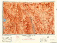
1956 Map of Death Valley
USGS Topo · Published 1956About this map
Death Valley dominates this mid-century landscape, a region defined by extreme elevations and isolated desert outposts. The map reveals a transition from the agricultural efforts at Furnace Creek Ranch and Furnace Creek to the industrial remains of the Eagle Borax Works. Settlement patterns follow the few reliable water sources, such as Bennetts Well, Texas Spring, and Indian Spring, while mining interests are scattered across the surrounding ranges, including the Modoc Mine and Rifle Silver Mine.
Find a feature on this map
144 named features on this map. Tap any name to fly to it.
Don’t see what you’re looking for? This feature index may not catch every label — zoom into the map to look around manually.
Map Details
Editions of this 1956 Death Valley Map
This is the sole edition of this map. No revisions or reprints were ever made.
Other maps of this area
1905 · Olancha
USGS Topo · 1:125,000
1906 · Kernville
USGS Topo · 1:125,000
1907 · Olancha
USGS Topo · 1:125,000
1907 · Mt. Whitney
USGS Topo · 1:125,000
1907 · Las Vegas
USGS Topo · 1:250,000
1908 · Kawich
USGS Topo · 1:250,000
1908 · Lida
USGS Topo · 1:250,000
1908 · Furnace Creek
USGS Topo · 1:250,000
1908 · Las Vegas
USGS Topo · 1:250,000
1908 · Kernville
USGS Topo · 1:125,000