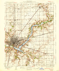
1933 Map of Decatur
USGS Topo · Published 1933About this map
Decatur serves as the focal point of this 1929 survey, showing the city's growth around the recently created Lake Decatur. This artificial reservoir on the Sangamon River transformed the local landscape, creating new recreational hubs such as Faries Park, the Decatur Country Club, and the Municipal Beach. The surrounding countryside in townships like Hickory Point and Whitmore is dotted with numerous rural institutions, from the Walnut Grove College Sch to the uniquely named Blue Door Sch.
Find a feature on this map
84 named features on this map. Tap any name to fly to it.
Don’t see what you’re looking for? This feature index may not catch every label — zoom into the map to look around manually.
Map Details
Editions of this 1933 Decatur Map
3 editions found
Other maps of this area

1929 · Decatur
USGS Topo · 1:62,500

1933 · Decatur
USGS Topo · 1:62,500

1935 · Sullivan
USGS Topo · 1:48,000

1937 · Monticello
USGS Topo · 1:48,000

1940 · Sullivan
USGS Topo · 1:62,500

1943 · Monticello
USGS Topo · 1:62,500

1949 · Dalton City
USGS Topo · 1:62,500

1952 · Assumption
USGS Topo · 1:62,500

1954 · Niantic
USGS Topo · 1:62,500

1955 · Bement
USGS Topo · 1:62,500