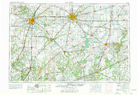
1958 Map of Decatur
USGS Topo · Published 1977About this map
Decatur and the central Illinois prairie landscape appear here during a period of significant post-war infrastructure expansion. The map detail highlights the convergence of major rail lines, including the Wabash RR and Illinois Central RR, which traditionally anchored the industrial economy of the region. As road travel increased, the emergence of the interstate system is evident with routes like I-55 and I-57 beginning to supersede the historic path of U.S. 66.
Find a feature on this map
129 named features on this map. Tap any name to fly to it.
Don’t see what you’re looking for? This feature index may not catch every label — zoom into the map to look around manually.
Map Details
Editions of this 1958 Decatur Map
3 editions found

Other maps of this area

1906 · Urbana
USGS Topo · 1:62,500

1907 · Springfield
USGS Topo · 1:62,500

1907 · Mahomet
USGS Topo · 1:62,500

1909 · Tallula
USGS Topo · 1:62,500

1910 · Hardinville
USGS Topo · 1:62,500

1911 · Lincoln
USGS Topo · 1:62,500

1912 · Gillespie
USGS Topo · 1:62,500

1913 · Lincoln
USGS Topo · 1:62,500

1915 · Gillespie
USGS Topo · 1:62,500

1915 · Mount Olive
USGS Topo · 1:62,500