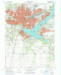
1967 Map of Decatur
USGS Topo · Published 1976About this map
Millikin University and the downtown core of Decatur anchor this 1960s study, showcasing the city's complex rail-and-river infrastructure. The Sangamon River is widened into Lake Decatur, spanned by the Staley Bridge and Lost Bridge, which connect the urban center to the expanding residential areas of South Wheatland and Mount Zion. The landscape is a dense network of industrial transit, with the Illinois Terminal, Baltimore and Ohio, and Norfolk and Western railroads converging near the city center.
Find a feature on this map
101 named features on this map. Tap any name to fly to it.
Don’t see what you’re looking for? This feature index may not catch every label — zoom into the map to look around manually.
Map Details
Editions of this 1967 Decatur Map
2 editions found
Other maps of this area

1929 · Decatur
USGS Topo · 1:62,500

1933 · Decatur
USGS Topo · 1:62,500

1949 · Dalton City
USGS Topo · 1:62,500

1952 · Assumption
USGS Topo · 1:62,500

1954 · Niantic
USGS Topo · 1:62,500

1958 · Decatur
USGS Topo · 1:250,000

1961 · Decatur
USGS Topo · 1:250,000

1967 · Long Creek
USGS Topo · 1:24,000
1967 · Argenta
USGS Topo · 1:24,000

1967 · Decatur
USGS Topo · 1:24,000