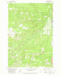
1979 Map of Dee
USGS Topo · Published 1980About this map
The confluence of the West Fork Hood River and the Middle Fork Hood River serves as the industrial and logistical heart of this landscape within the Mount Hood National Forest. The settlement of Dee stands at this junction, tied to the outside world by the winding route of the Mount Hood Railroad. This 1970s survey captures a geography defined by timber and water management, evidenced by the extensive network of labels for Ditch, Flume, and an Aqueduct system traversing the steep terrain of Blowdown Ridge.
Find a feature on this map
52 named features on this map. Tap any name to fly to it.
Don’t see what you’re looking for? This feature index may not catch every label — zoom into the map to look around manually.
Map Details
Editions of this 1979 Dee Map
This is the sole edition of this map. No revisions or reprints were ever made.
Other maps of this area

1924 · Mount Hood
USGS Topo · 1:125,000

1926 · Hood River
USGS Topo · 1:125,000

1927 · Mount Hood
USGS Topo · 1:125,000

1929 · Hood River
USGS Topo · 1:125,000

1953 · The Dalles
USGS Topo · 1:250,000

1956 · The Dalles
USGS Topo · 1:250,000

1957 · The Dalles
USGS Topo · 1:250,000

1957 · Bonneville Dam
USGS Topo · 1:62,500

1957 · Hood River
USGS Topo · 1:62,500

1962 · Cathedral Ridge
USGS Topo · 1:24,000