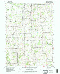
1992 Map of Deedsville
USGS Topo · Published 1995About this map
The Old Indian Treaty Boundary slices diagonally across this agricultural landscape, a persistent historical line that continues to influence the platting of fields and roads in rural northern Indiana. Centered on the village of Deedsville, the area is defined by a dense network of water management features like Taylor Ditch and Pleasant Hill Ditch, which drain the low-lying terrain into larger courses such as Weesau Creek and Flowers Creek. These watercourses dictate the placement of small rural hubs like Gilead and Macy, which appear here as they stood in the early 1990s.
Find a feature on this map
45 named features on this map. Tap any name to fly to it.
Don’t see what you’re looking for? This feature index may not catch every label — zoom into the map to look around manually.
Map Details
Editions of this 1992 Deedsville Map
This is the sole edition of this map. No revisions or reprints were ever made.
Other maps of this area

1951 · Peru
USGS Topo · 1:24,000

1951 · Twelve Mile
USGS Topo · 1:24,000

1951 · Richvalley
USGS Topo · 1:24,000

1953 · Fort Wayne
USGS Topo · 1:250,000

1953 · Chicago
USGS Topo · 1:250,000

1953 · Danville
USGS Topo · 1:250,000

1953 · Muncie
USGS Topo · 1:250,000

1955 · Danville
USGS Topo · 1:250,000

1956 · Muncie
USGS Topo · 1:250,000

1956 · Danville
USGS Topo · 1:250,000