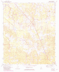
1972 Map of Deemer
USGS Topo · Published 1982About this map
The Choctaw Indian Reservation dominates the central portion of this Neshoba County landscape, reflecting the long-standing indigenous heritage of east-central Mississippi. In the early 1970s, the rural character of the area was defined by dispersed settlements like Deemer, Spring Hill, and Tucker, many of which centered around community anchors such as the Spring Hill Cem and Center Hill Cem. Local commerce and movement are etched into the terrain via the Beatline road and the engineered water management of the Cushtusia Canal and Coonshuck Canal. Near the community of Bethsaida, the land rises toward Rock Gut Hill and Circle Hill, while scattered sandpits indicate the local extractive industry of the period. This survey captures a moment of transition, showing the intersection of traditional agricultural settlements with regional infrastructure like the Gaging Station and the Radio Tower.
Find a feature on this map
26 named features on this map. Tap any name to fly to it.
Don’t see what you’re looking for? This feature index may not catch every label — zoom into the map to look around manually.
Map Details
Editions of this 1972 Deemer Map
2 editions found
Other maps of this area

1953 · Meridian
USGS Topo · 1:250,000

1957 · Meridian
USGS Topo · 1:250,000

1962 · House
USGS Topo · 1:24,000

1962 · Owl Creek
USGS Topo · 1:24,000

1962 · Post
USGS Topo · 1:24,000

1965 · Meridian
USGS Topo · 1:250,000

1972 · Pearl River
USGS Topo · 1:24,000

1972 · Deemer
USGS Topo · 1:24,000

1972 · Union East
USGS Topo · 1:24,000
1972 · Philadelphia
USGS Topo · 1:24,000