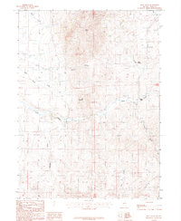
1987 Map of Deep Creek
USGS Topo · Published 1987About this map
Wilson Peak dominates the northern reaches of this high-desert landscape in Elko County, marking a high point in a complex network of canyons and ridgelines. The area shows clear evidence of resource extraction and transit at the IL Summit, where several unimproved roads and trails converge. The presence of the Lime Mountain Mine and a nearby Gravel Pit indicates the industrial activity that sustained local operations in this corner of Nevada. Water sources are critical here, with Mud Spring and Warm Spring Creek feeding into the larger drainage systems. The map traces the winding paths of Deep Creek and Chicken Creek, illustrating how the terrain’s verticality shapes the flow of seasonal water through Wilson Canyon and Long Hollow. This survey provides a precise view of the geographic isolation and geological character of the region as it was documented in the late 1980s.
Find a feature on this map
13 named features on this map. Tap any name to fly to it.
Don’t see what you’re looking for? This feature index may not catch every label — zoom into the map to look around manually.
Map Details
Editions of this 1987 Deep Creek Map
This is the sole edition of this map. No revisions or reprints were ever made.
Other maps of this area

1955 · McDermitt
USGS Topo · 1:250,000

1956 · Tuscarora
USGS Topo · 1:62,500

1956 · Mt. Blitzen
USGS Topo · 1:62,500

1956 · Bull Run
USGS Topo · 1:62,500

1959 · McDermitt
USGS Topo · 1:250,000

1964 · Wilson Reservoir
USGS Topo · 1:62,500

1982 · Bull Run Mts
USGS Topo · 1:100,000

1982 · Tuscarora
USGS Topo · 1:100,000
1987 · Cottonwood Peak
USGS Topo · 1:24,000
1987 · Big Cottonwood Canyon
USGS Topo · 1:24,000