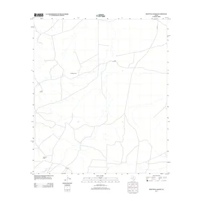
2012 Map of Deep Well Ranch
USGS Topo · Published 2012About this map
Deep Well Ranch and the remote expanse of Pecos County define this 2012 survey, where the sparse landscape of West Texas is marked by isolated water sources and long-established homesteads. The terrain is characterized by ephemeral drainages such as Addoson Draw and the southern reaches of Limpia Cr, which flow through a region of scattered ranching infrastructure. Landmarks like the Dutch Windmill and The Monument serve as essential navigational points in an area where human activity is centered on livestock management and water access. Significant local landmarks include Stone Ranch in the south and the namesake Deep Well Ranch further north, both connected by a network of ranch roads and Hovey Rd. This map captures the modern layout of these large landholdings, providing clear documentation of the fences, roads, and tanks that sustain cattle operations in this arid environment.
Find a feature on this map
7 named features on this map. Tap any name to fly to it.
Don’t see what you’re looking for? This feature index may not catch every label — zoom into the map to look around manually.
Map Details
Editions of this 2012 Deep Well Ranch Map
This is the sole edition of this map. No revisions or reprints were ever made.
Other maps of this area

1894 · Fort Davis
USGS Topo · 1:125,000

1897 · Fort Davis
USGS Topo · 1:125,000

1929 · Hovey
USGS Topo · 1:125,000

1954 · Fort Stockton
USGS Topo · 1:250,000

1958 · Fort Stockton
USGS Topo · 1:250,000

1970 · Tucker Hill
USGS Topo · 1:24,000

1970 · Deep Well Ranch
USGS Topo · 1:24,000

1970 · Deep Well Ranch SE
USGS Topo · 1:24,000
1970 · Deep Well Ranch NW
USGS Topo · 1:24,000

1973 · Fort Stockton
USGS Topo · 1:250,000