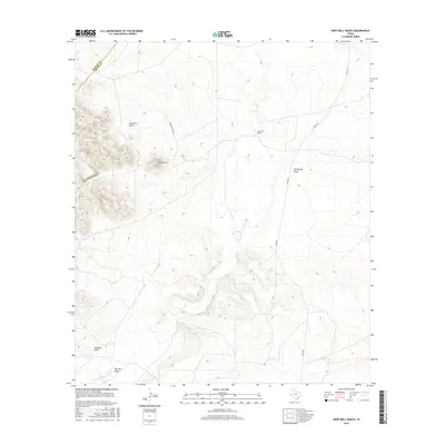
2016 Map of Deep Well Ranch
USGS Topo · Published 2016About this map
Deep Well Ranch sits within a landscape defined by an intricate network of drainage channels in this high-desert portion of West Texas. The terrain is dominated by significant seasonal watercourses including Lawrence Draw, Hackberry Draw, and Addoson Draw, which navigate the elevation shifts of the Trans-Pecos region. A prominent topographical feature known as The Monument serves as a distinct landmark against the surrounding contours, while the southern boundary of the quadrangle is marked by Limpia Cr and Barrilla Draw. Infrastructure is sparse, characterized by the reach of Hovey Rd and a dedicated Ranch Access Rd, reflecting the remote ranching operations and large-acreage land use typical of Pecos County during this era.
Find a feature on this map
10 named features on this map. Tap any name to fly to it.
Don’t see what you’re looking for? This feature index may not catch every label — zoom into the map to look around manually.
Map Details
Editions of this 2016 Deep Well Ranch Map
This is the sole edition of this map. No revisions or reprints were ever made.
Other maps of this area

1894 · Fort Davis
USGS Topo · 1:125,000

1897 · Fort Davis
USGS Topo · 1:125,000

1929 · Hovey
USGS Topo · 1:125,000

1954 · Fort Stockton
USGS Topo · 1:250,000

1958 · Fort Stockton
USGS Topo · 1:250,000

1970 · Tucker Hill
USGS Topo · 1:24,000

1970 · Deep Well Ranch
USGS Topo · 1:24,000

1970 · Deep Well Ranch SE
USGS Topo · 1:24,000
1970 · Deep Well Ranch NW
USGS Topo · 1:24,000

1973 · Fort Stockton
USGS Topo · 1:250,000