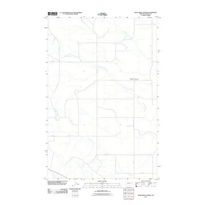
2011 Map of Deer Creek Church
USGS Topo · Published 2011About this map
Deer Creek Church and the adjacent West Church Cemetery serve as the primary landmarks in this sparsely populated portion of Dawson County. The landscape is defined by the branching drainage systems of the Middle Fork Deer Creek, South Fork Deer Creek, and Spring Creek, which carve across the eastern Montana plains. This 2011 survey reveals a rural infrastructure organized around a strictly surveyed grid of section lines and secondary routes like Fas 470 and Road 452. The placement of these community institutions at the junction of Road 446 suggests a long-standing local center for the surrounding ranching or agricultural operations, providing genealogists and local historians a precise look at these rural cornerstones at the start of the 21st century.
Find a feature on this map
12 named features on this map. Tap any name to fly to it.
Don’t see what you’re looking for? This feature index may not catch every label — zoom into the map to look around manually.
Map Details
Editions of this 2011 Deer Creek Church Map
This is the sole edition of this map. No revisions or reprints were ever made.
Other maps of this area

1954 · Glendive
USGS Topo · 1:250,000

1957 · Glendive
USGS Topo · 1:250,000

1958 · Glendive
USGS Topo · 1:250,000

1982 · Circle
USGS Topo · 1:100,000

1983 · Johnson Reservoir NW
USGS Topo · 1:24,000
1983 · Union School
USGS Topo · 1:24,000
1983 · Johnson Reservoir
USGS Topo · 1:24,000

1983 · Olson Coulee South
USGS Topo · 1:24,000
1983 · Woodrow
USGS Topo · 1:24,000

1983 · Deer Creek Church
USGS Topo · 1:24,000