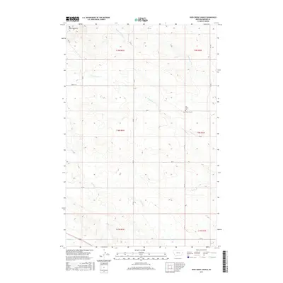
2017 Map of Deer Creek Church
USGS Topo · Published 2017About this map
Deer Creek Church and the adjacent West Church Cem serve as the primary landmarks in this sparsely settled corner of Dawson County. The landscape is defined by the headwaters of several drainage systems, including the Middle Fork Deer Cr and S Fork Deer Cr, which carve through the high plains. In the northwest corner, the terrain rises toward the Big Sheep Mountains, a significant topographical feature that influences the local water table and drainage patterns. The road network consists primarily of secondary routes like Fas 470 and local tracks such as Pasture Trl, illustrating the agricultural and ranching character of the region. This 2017 survey captures the enduring rural footprint of eastern Montana, where small community centers and family cemeteries remain the focal points for local history and genealogy.
Find a feature on this map
21 named features on this map. Tap any name to fly to it.
Don’t see what you’re looking for? This feature index may not catch every label — zoom into the map to look around manually.
Map Details
Editions of this 2017 Deer Creek Church Map
This is the sole edition of this map. No revisions or reprints were ever made.
Other maps of this area

1954 · Glendive
USGS Topo · 1:250,000

1957 · Glendive
USGS Topo · 1:250,000

1958 · Glendive
USGS Topo · 1:250,000

1982 · Circle
USGS Topo · 1:100,000

1983 · Johnson Reservoir NW
USGS Topo · 1:24,000
1983 · Union School
USGS Topo · 1:24,000
1983 · Johnson Reservoir
USGS Topo · 1:24,000

1983 · Olson Coulee South
USGS Topo · 1:24,000
1983 · Woodrow
USGS Topo · 1:24,000

1983 · Deer Creek Church
USGS Topo · 1:24,000