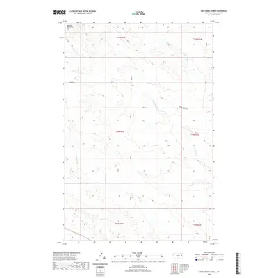
2020 Map of Deer Creek Church
USGS Topo · Published 2020About this map
Deer Creek Church and the adjacent West Church Cem serve as a focal point for this rural Dawson County landscape, where the prairie begins to rise toward the prominent elevation of Big Sheep Mountain. The map details an intricate network of drainages that define the local topography, including the Middle Fork Deer Cr and S Fork Deer Cr. These seasonal waterways are supplemented by Spring Cr and Hay Cr, illustrating the vital importance of water management in eastern Montana's ranching country. The land is organized by a system of rural roads and tracks, such as RD 452 and the descriptive Pasture Trl, which follow the contours of the terrain and provide access between the various township sections.
Find a feature on this map
21 named features on this map. Tap any name to fly to it.
Don’t see what you’re looking for? This feature index may not catch every label — zoom into the map to look around manually.
Map Details
Editions of this 2020 Deer Creek Church Map
This is the sole edition of this map. No revisions or reprints were ever made.
Other maps of this area

1954 · Glendive
USGS Topo · 1:250,000

1957 · Glendive
USGS Topo · 1:250,000

1958 · Glendive
USGS Topo · 1:250,000

1982 · Circle
USGS Topo · 1:100,000

1983 · Johnson Reservoir NW
USGS Topo · 1:24,000
1983 · Union School
USGS Topo · 1:24,000
1983 · Johnson Reservoir
USGS Topo · 1:24,000

1983 · Olson Coulee South
USGS Topo · 1:24,000
1983 · Woodrow
USGS Topo · 1:24,000

1983 · Deer Creek Church
USGS Topo · 1:24,000