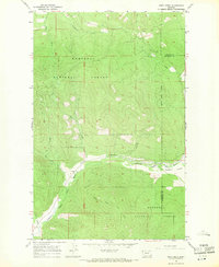
1966 Map of Deer Creek
USGS Topo · Published 1971About this map
Pleasant Valley and the course of the Fisher River dominate this mid-1960s survey within the Kootenai National Forest. The landscape is defined by its drainage network, where the Pleasant Valley Fisher River meets numerous mountain tributaries including Calx Creek, Tamarack Creek, and Tensaw Creek. This area, straddling the border between Lincoln and Flathead counties, reflects a timber and resource-based economy where early infrastructure is limited to a handful of unpaved routes and a Gravel Pit near the river bend.
Find a feature on this map
17 named features on this map. Tap any name to fly to it.
Don’t see what you’re looking for? This feature index may not catch every label — zoom into the map to look around manually.
Map Details
Editions of this 1966 Deer Creek Map
2 editions found
Other maps of this area

1920 · Jennings
USGS Topo · 1:125,000

1935 · Thompson Lakes
USGS Topo · 1:96,000

1942 · Thompson Lakes
USGS Topo · 1:125,000

1957 · Kalispell
USGS Topo · 1:250,000

1960 · Kalispell
USGS Topo · 1:250,000

1961 · Kalispell
USGS Topo · 1:250,000

1963 · Wolf Prairie
USGS Topo · 1:24,000
1963 · Horse Hill
USGS Topo · 1:24,000
1963 · Richards Mountain
USGS Topo · 1:24,000

1964 · Meadow Peak
USGS Topo · 1:24,000