1970 Map of Deer Lake East
USGS Topo · Published 1973About this map
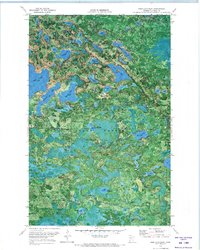
George Washington State Forest dominates this northern landscape, which is defined by an intricate network of lakes and seasonal transit routes. In the early 1970s, the terrain was accessed through a series of specialized paths, including the Winter Trail, Winter Road, and Buttonbox Lake Road. An Old Railroad Grade cutting across the central portion of the sheet provides evidence of earlier logging or industrial activity that preceded the 1970 survey. Large bodies of water such as Deer Lake, Battle Lake, and Five Island Lake are interspersed with smaller named features like Lake Seventeen and Thistledew Lake. This orthophotomap, which utilizes high-altitude aerial photography, captures the dense forest cover and the scattered infrastructure of the era, including a Gravel Pit and a lakeside Campground.
Find a feature on this map
39 named features on this map. Tap any name to fly to it.
Don’t see what you’re looking for? This feature index may not catch every label — zoom into the map to look around manually.
Map Details
Editions of this 1970 Deer Lake East Map
This is the sole edition of this map. No revisions or reprints were ever made.
Other maps of this area

1919 · Release
USGS Topo · 1:62,500

1943 · Release
USGS Topo · 1:62,500

1954 · Hibbing
USGS Topo · 1:250,000

1957 · Hibbing
USGS Topo · 1:250,000

1958 · Hibbing
USGS Topo · 1:250,000

1964 · Hibbing
USGS Topo · 1:250,000
1964 · Sherry Lake
USGS Topo · 1:24,000

1970 · Rauch
USGS Topo · 1:24,000
1970 · Anderson Lake
USGS Topo · 1:24,000

1970 · Deer Lake NE
USGS Topo · 1:24,000