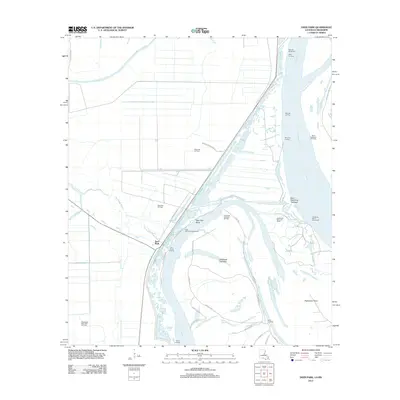
2012 Map of Deer Park
USGS Topo · Published 2012About this map
The community of Deer Park is situated along a sharp bend of the Old River in Concordia Parish, where the local economy and geography are defined by the shifting course of the Mississippi Delta. In the early 21st century, the area shows a distinct pattern of resource extraction and river management, evidenced by numerous production sites such as the Warnicott Oil Field and the Southwest Deer Park Oil Field. The hydraulic engineering of the river is visible through features like the Morville Revetment and Catherine Bend Revetment, which protect the banks and redirect the powerful flow of the Mississippi River. Numerous historical river access points are documented, including Moro Landing, Warnicott Landing, and Fish Pond Landing. These landmarks, along with Glasscock Towhead and Esperance Point, illustrate the dynamic nature of the fluvial landscape where abandoned channels like Briars Chute and Mississippi Bayou create a network of waterways and wetlands.
Find a feature on this map
38 named features on this map. Tap any name to fly to it.
Don’t see what you’re looking for? This feature index may not catch every label — zoom into the map to look around manually.
Map Details
Editions of this 2012 Deer Park Map
This is the sole edition of this map. No revisions or reprints were ever made.
Other maps of this area

1909 · Sycamore Landing
USGS Topo · 1:24,000

1909 · Vidalia
USGS Topo · 1:24,000

1921 · Natchez
USGS Topo · 1:48,000

1922 · Natchez
USGS Topo · 1:62,500

1939 · Red Gum
USGS Topo · 1:62,500

1939 · Natchez
USGS Topo · 1:62,500

1939 · Kingston
USGS Topo · 1:62,500

1939 · Deer Park
USGS Topo · 1:62,500

1953 · Natchez
USGS Topo · 1:250,000

1956 · Natchez
USGS Topo · 1:250,000