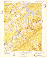
1949 Map of Deer Park
USGS Topo · Published 1949About this map
The Baltimore and Ohio railroad corridor anchors this post-war survey of the Allegheny Plateau, connecting the industrial and residential hubs of Deer Park, Mountain Lake Park, and Loch Lynn Heights. The landscape is defined by the massive ridge of Backbone Mountain and the growing recreational draw of Deep Creek Lake to the north. This era captures the early development of seasonal tourism, evidenced by the Deep Creek Ski Lift and organized retreats like Boy Scout Camp and Holy Cross Camp.
Find a feature on this map
62 named features on this map. Tap any name to fly to it.
Don’t see what you’re looking for? This feature index may not catch every label — zoom into the map to look around manually.
Map Details
Editions of this 1949 Deer Park Map
2 editions found
Other maps of this area

1895 · Piedmont
USGS Topo · 1:125,000

1899 · Grantsville
USGS Topo · 1:62,500

1899 · Oakland
USGS Topo · 1:62,500

1900 · Accident
USGS Topo · 1:62,500

1900 · Oakland
USGS Topo · 1:62,500

1904 · Grantsville
USGS Topo · 1:62,500

1919 · Elk Garden
USGS Topo · 1:48,000

1920 · Elk Garden
USGS Topo · 1:48,000

1922 · Elk Garden
USGS Topo · 1:62,500
1947 · Sang Run
USGS Topo · 1:24,000