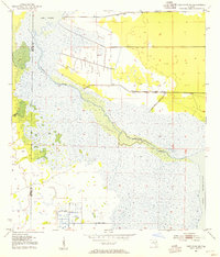
1953 Map of Deer Park NE
USGS Topo · Published 1954About this map
The St Johns River meanders through this portion of the Florida interior, connecting expansive water bodies such as Lake Winder and Lake Washington. This 1953 topographic study, compiled from earlier aerial photography, captures a landscape defined by wetlands and hydrological engineering. Several instances of a Spoil Bank appear alongside straight-line drainage or excavation projects, reflecting mid-century efforts to manage the river's basin. While the terrain is dominated by marshes and natural waterways like Pennywash Creek, early industrial activity is evidenced by scattered Well sites. The map also delineates the jurisdictional boundary between Osceola and Brevard counties, providing a clear look at the undeveloped character of the region before the rapid expansion of East Central Florida.
Find a feature on this map
10 named features on this map. Tap any name to fly to it.
Don’t see what you’re looking for? This feature index may not catch every label — zoom into the map to look around manually.
Map Details
Editions of this 1953 Deer Park NE Map
5 editions found
Other maps of this area

1949 · Melbourne West
USGS Topo · 1:24,000

1949 · Eau Gallie
USGS Topo · 1:24,000

1949 · Cocoa
USGS Topo · 1:24,000

1951 · Eau Gallie
USGS Topo · 1:24,000

1951 · Cocoa
USGS Topo · 1:24,000

1951 · Melbourne West
USGS Topo · 1:24,000

1953 · Lake Poinsett
USGS Topo · 1:24,000

1953 · Deer Park NE
USGS Topo · 1:24,000

1953 · Deer Park SE
USGS Topo · 1:24,000

1953 · Deer Park NW
USGS Topo · 1:24,000