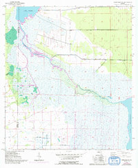
1953 Map of Deer Park NE
USGS Topo · Published 1992About this map
The St Johns River meanders across this landscape, connecting significant water bodies in east-central Florida. This 1953 topographic survey, based on aerial photography from 1951, reveals the natural hydrology of the region before significant modern development altered the drainage patterns. Large expanses of marshland surround Lake Winder and reach toward the shores of Lake Washington, while Pennywash Creek feeds into the central basin. Evidence of early land management and drainage efforts appear in the form of multiple Spoil Bank markings along the river and canal systems. The boundary between Osceola County and Brevard County cuts through the western portion of the sheet, providing a clear reference for researchers tracing historic property lines and jurisdictional limits in this wetland environment.
Find a feature on this map
7 named features on this map. Tap any name to fly to it.
Don’t see what you’re looking for? This feature index may not catch every label — zoom into the map to look around manually.
Map Details
Editions of this 1953 Deer Park NE Map
5 editions found
Other maps of this area

1949 · Melbourne West
USGS Topo · 1:24,000

1949 · Eau Gallie
USGS Topo · 1:24,000

1949 · Cocoa
USGS Topo · 1:24,000

1951 · Eau Gallie
USGS Topo · 1:24,000

1951 · Cocoa
USGS Topo · 1:24,000

1951 · Melbourne West
USGS Topo · 1:24,000

1953 · Lake Poinsett
USGS Topo · 1:24,000

1953 · Deer Park NE
USGS Topo · 1:24,000

1953 · Deer Park SE
USGS Topo · 1:24,000

1953 · Deer Park NW
USGS Topo · 1:24,000