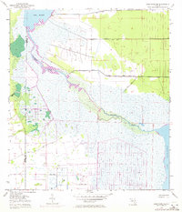
1953 Map of Deer Park NE
USGS Topo · Published 1970About this map
St Johns River defines the landscape of this Central Florida corridor, winding through a complex system of marshes and wetlands between Lake Winder and Lake Washington. Based on 1950s surveys with 1970 revisions, the map illustrates the early engineering efforts to manage the river's floodplains, marked by several prominent Spoil Bank features along its course and drainage channels. The boundary between Osceola and Brevard counties cuts through this watery wilderness, where Pennywash Creek feeds into the main channel. Aside from scattered agricultural infrastructure such as a Well, the area remains dominated by its natural hydrology, capturing a moment before extensive suburban development reached these riverine reaches.
Find a feature on this map
7 named features on this map. Tap any name to fly to it.
Don’t see what you’re looking for? This feature index may not catch every label — zoom into the map to look around manually.
Map Details
Editions of this 1953 Deer Park NE Map
5 editions found
Other maps of this area

1949 · Melbourne West
USGS Topo · 1:24,000

1949 · Eau Gallie
USGS Topo · 1:24,000

1949 · Cocoa
USGS Topo · 1:24,000

1951 · Eau Gallie
USGS Topo · 1:24,000

1951 · Cocoa
USGS Topo · 1:24,000

1951 · Melbourne West
USGS Topo · 1:24,000

1953 · Lake Poinsett
USGS Topo · 1:24,000

1953 · Deer Park NE
USGS Topo · 1:24,000

1953 · Deer Park SE
USGS Topo · 1:24,000

1953 · Deer Park NW
USGS Topo · 1:24,000