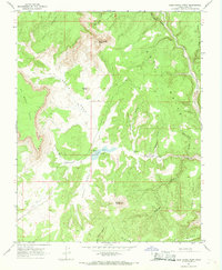
1966 Map of Deer Range Point
USGS Topo · Published 1968About this map
Nipple Ranch sits at the heart of this Kane County landscape, where the high desert terrain is defined by dramatic geological formations. The map depicts a complex network of canyons and plateaus, from the towering White Cliffs and No Mans Mesa in the west to the Deer Trails and the Paria River in the east. The land is marked by significant topographical landmarks like Mollies Nipple and Potters Butte, which likely served as crucial navigational aids for early ranchers and travelers. Movement through the area is limited to a handful of Jeep Trails that traverse the North Swag and West Swag, highlighting the region's isolated character during the mid-1960s. Water sources, vital for livestock and settlement, are documented at Nipple Springs and along Deer Creek, illustrating how the desert hydrology dictated the placement of local infrastructure.
Find a feature on this map
26 named features on this map. Tap any name to fly to it.
Don’t see what you’re looking for? This feature index may not catch every label — zoom into the map to look around manually.
Map Details
Editions of this 1966 Deer Range Point Map
This is the sole edition of this map. No revisions or reprints were ever made.
Other maps of this area

1886 · Kanab
USGS Topo · 1:250,000

1886 · Escalante
USGS Topo · 1:250,000

1953 · Cedar City
USGS Topo · 1:250,000

1954 · Buckskin Gulch NW
USGS Topo · 1:24,000

1954 · Buckskin Gulch NE
USGS Topo · 1:24,000

1954 · Paria NW
USGS Topo · 1:24,000

1954 · Buckskin Gulch
USGS Topo · 1:62,500

1954 · Paria
USGS Topo · 1:62,500

1955 · The Cockscob SW
USGS Topo · 1:24,000

1956 · Escalante
USGS Topo · 1:250,000