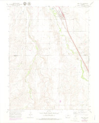
1969 Map of Deer Trail
USGS Topo · Published 1979About this map
Deer Trail serves as the primary hub in this High Plains landscape, situated at the intersection of the Union Pacific railroad and the natural drainage of East Bijou Creek. The town's local infrastructure is well-defined, featuring the Evergreen Cem on its eastern edge and a dedicated Rodeo Ground near the rail corridor. Numerous storage bins positioned alongside the tracks highlight the area's agricultural reliance on rail transport for moving grain and livestock.
Find a feature on this map
18 named features on this map. Tap any name to fly to it.
Don’t see what you’re looking for? This feature index may not catch every label — zoom into the map to look around manually.
Map Details
Editions of this 1969 Deer Trail Map
3 editions found
Other maps of this area

1891 · Limon
USGS Topo · 1:125,000

1892 · Limon
USGS Topo · 1:125,000

1953 · Denver
USGS Topo · 1:250,000

1954 · Limon
USGS Topo · 1:250,000

1956 · Peoria
USGS Topo · 1:24,000

1956 · Byers
USGS Topo · 1:24,000

1957 · Denver
USGS Topo · 1:250,000

1957 · Limon
USGS Topo · 1:250,000

1958 · Limon
USGS Topo · 1:250,000

1958 · Denver
USGS Topo · 1:250,000