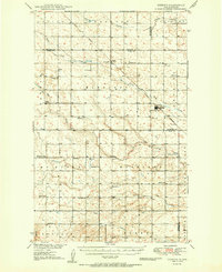
1950 Map of Deering
USGS Topo · Published 1950About this map
Agricultural lands across the border of McHenry, Ward, and Renville Counties dominate this mid-century survey, defined by the winding paths of Little Deep Creek and Egg Creek. The town of Deering serves as the primary hub along the Great Northern railroad, which cuts diagonally across the prairie landscape. This era shows a distributed network of rural life, with numerous numbered schoolhouses and country churches such as Nidarose Ch and Bethany Ch anchoring the surrounding townships. Local drainage patterns are detailed through features like Spring Coulee and Hay Coulee, illustrating the hydrological character of the region before significant modern alteration. Smaller settlements like Wolseth and landmarks such as a Radio Sta and the Bethel Cem provide specific points of interest for those tracing the development of these North Dakota communities.
Find a feature on this map
21 named features on this map. Tap any name to fly to it.
Don’t see what you’re looking for? This feature index may not catch every label — zoom into the map to look around manually.
Map Details
Editions of this 1950 Deering Map
2 editions found
Other maps of this area

1928 · Minot
USGS Topo · 1:62,500

1929 · Sawyer
USGS Topo · 1:62,500

1948 · Lansford
USGS Topo · 1:62,500

1948 · Velva
USGS Topo · 1:62,500

1948 · Burlington
USGS Topo · 1:62,500

1948 · Newburg SW
USGS Topo · 1:24,000

1948 · Surrey
USGS Topo · 1:24,000

1949 · Glenburn
USGS Topo · 1:24,000

1949 · Norwich
USGS Topo · 1:24,000

1949 · Sawyer NE
USGS Topo · 1:24,000