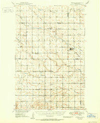
1950 Map of Deering
USGS Topo · Published 1950About this map
Deering serves as the central hub of this North Dakota landscape, where the Great Northern railroad cuts a diagonal line through the prairie. The map records a dense network of early rural social centers, including numerous numbered schools and vital community gathering places like Nidarose Ch, Bethany Ch, and Emmanuel Ch. These landmarks, alongside the Bethel Cem and Deering Cem, provide essential anchor points for genealogists tracing family roots in McHenry and Ward counties.
Find a feature on this map
29 named features on this map. Tap any name to fly to it.
Don’t see what you’re looking for? This feature index may not catch every label — zoom into the map to look around manually.
Map Details
Editions of this 1950 Deering Map
2 editions found
Other maps of this area

1928 · Minot
USGS Topo · 1:62,500

1929 · Sawyer
USGS Topo · 1:62,500

1948 · Lansford
USGS Topo · 1:62,500

1948 · Velva
USGS Topo · 1:62,500

1948 · Burlington
USGS Topo · 1:62,500

1948 · Newburg SW
USGS Topo · 1:24,000

1948 · Surrey
USGS Topo · 1:24,000

1949 · Glenburn
USGS Topo · 1:24,000

1949 · Norwich
USGS Topo · 1:24,000

1949 · Sawyer NE
USGS Topo · 1:24,000