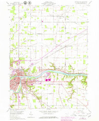
1959 Map of Defiance East
USGS Topo · Published 1979About this map
The confluence of the Maumee River and the Auglaize River anchor this late-1950s survey of Defiance, Ohio. The landscape illustrates a transition from the historic river-based transport of the Miami and Erie Canal (Abandoned) to the heavy rail corridors of the Norfolk and Western and the Baltimore and Ohio railroads. Settlement is concentrated at the city center around Defiance College and Old Fort Defiance Park, while the surrounding townships of Richland and Adams maintain a grid of family-named roads like Gerken Road and Shindler Road. Local infrastructure is highly visible, from the Independence Dam on the Maumee to the various parish churches and cemeteries, such as St Michaels Ch and the Hohenberger Cem, which serve as vital markers for genealogical research in these rural communities.
Find a feature on this map
69 named features on this map. Tap any name to fly to it.
Don’t see what you’re looking for? This feature index may not catch every label — zoom into the map to look around manually.
Map Details
Editions of this 1959 Defiance East Map
3 editions found
Other maps of this area

1907 · Defiance
USGS Topo · 1:62,500

1908 · Ottawa
USGS Topo · 1:62,500

1908 · Napoleon
USGS Topo · 1:62,500

1909 · Defiance
USGS Topo · 1:62,500

1909 · Continental
USGS Topo · 1:62,500

1953 · Fort Wayne
USGS Topo · 1:250,000

1956 · Fort Wayne
USGS Topo · 1:250,000

1959 · Defiance East
USGS Topo · 1:24,000
1959 · Ridgeville Corners
USGS Topo · 1:24,000

1959 · Florida
USGS Topo · 1:24,000