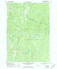
1969 Map of Degrasse
USGS Topo · Published 1984About this map
Degrasse sits at a geographic crossroads in St. Lawrence County, where the Middle Branch Grass River meets the south branch. This late 1960s landscape is defined by the transition from settled townships like Russell and Clare into the protected wilderness of Adirondack State Park. Remnants of the region's industrial past are visible near Orebed Ponds, where the Clifton Furnace Ruins remain as a marker of the 19th-century iron industry that once thrived in these northern woods. The map highlights a network of water and terrain, from the rugged elevations of Silver Hill to the cascading waters at Twin Falls and Flat Rock Falls. Local history is preserved in sites like the Pleasant View Cem, while the presence of a Landing Strip and numerous jeep trails suggests a landscape utilized for both forestry management and remote recreation within the Degrasse State Forest.
Find a feature on this map
51 named features on this map. Tap any name to fly to it.
Don’t see what you’re looking for? This feature index may not catch every label — zoom into the map to look around manually.
Map Details
Editions of this 1969 Degrasse Map
3 editions found
Other maps of this area

1915 · Russell
USGS Topo · 1:62,500

1916 · Oswegatchie
USGS Topo · 1:62,500

1918 · Russell
USGS Topo · 1:62,500

1918 · Oswegatchie
USGS Topo · 1:62,500

1919 · Cranberry Lake
USGS Topo · 1:62,500

1921 · Cranberry Lake
USGS Topo · 1:62,500

1921 · Stark
USGS Topo · 1:62,500

1923 · Stark
USGS Topo · 1:62,500

1931 · Cranberry Lake
USGS Topo · 1:62,500

1940 · Stark
USGS Topo · 1:62,500