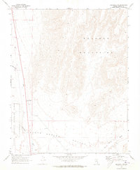
1969 Map of Delamar 3 SW
USGS Topo · Published 1973About this map
Coyote Spring Valley dominates this arid landscape, where the southern reaches of the Delamar Mountains meet the vast drainage basins of Lincoln County. Recorded through 1967 aerial photography and field-checked in 1969, the map captures a pivotal corridor of southeastern Nevada where Pahranagat Wash and Kane Springs Wash converge. A significant historical detail is the Old State Boundary Historical Marker, situated near the western edge of the valley. This marker signifies an earlier territorial era and sits just east of the Desert National Wildlife Range boundary. The alignment of U.S. Route 93 serves as the primary modern artery through this basin-and-range terrain, tracing the natural path carved by the washes.
Find a feature on this map
7 named features on this map. Tap any name to fly to it.
Don’t see what you’re looking for? This feature index may not catch every label — zoom into the map to look around manually.
Map Details
Editions of this 1969 Delamar 3 SW Map
3 editions found
Other maps of this area

1885 · Pioche
USGS Topo · 1:250,000

1886 · Saint Thomas
USGS Topo · 1:250,000

1886 · Pioche
USGS Topo · 1:250,000

1893 · Saint Thomas
USGS Topo · 1:250,000

1907 · Las Vegas
USGS Topo · 1:250,000

1908 · Las Vegas
USGS Topo · 1:250,000

1945 · Sheep Range
USGS Topo · 1:125,000

1945 · Alamo
USGS Topo · 1:125,000

1954 · Caliente
USGS Topo · 1:250,000

1954 · Las Vegas
USGS Topo · 1:250,000