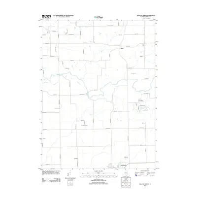
2012 Map of Delavan North
USGS Topo · Published 2012About this map
Dillon and northern Delavan anchor this Tazewell County landscape, where the meandering Mackinaw River cuts through the prairie. The map documents a predominantly agricultural region defined by a precise grid of rural roads like Townline Rd and Springfield Rd. Small clusters of development at Herget and Holmes appear alongside family-held landmarks such as River Valley Farm. For those tracing local heritage, the map identifies several well-established burial grounds, including Woodrow Cem, Antioch Cem, and Saint Mary's Catholic Cem. This 2012 survey also highlights the area's private aviation infrastructure, noting both the Lutz RLA Airport and Orwig RLA Airport. Drainage patterns are clearly marked by the paths of Dillon Cr and Dry Cr, which flow toward the primary river channel in the center of the quadrangle.
Find a feature on this map
68 named features on this map. Tap any name to fly to it.
Don’t see what you’re looking for? This feature index may not catch every label — zoom into the map to look around manually.
Map Details
Editions of this 2012 Delavan North Map
This is the sole edition of this map. No revisions or reprints were ever made.
Other maps of this area

1905 · Peoria
USGS Topo · 1:62,500

1927 · Peoria
USGS Topo · 1:62,500

1928 · Mackinaw
USGS Topo · 1:62,500

1932 · Mackinaw
USGS Topo · 1:62,500

1942 · Delavan
USGS Topo · 1:62,500

1951 · Minier
USGS Topo · 1:62,500

1958 · Peoria
USGS Topo · 1:250,000

1960 · Marquette Heights
USGS Topo · 1:24,000

1960 · Pekin
USGS Topo · 1:24,000

1961 · Peoria
USGS Topo · 1:250,000