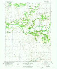
1971 Map of Delavan North
USGS Topo · Published 1973About this map
The Mackinaw River carves a winding path through this portion of Tazewell County, defining the agricultural and industrial landscape between the settlements of Delavan and Dillon. The map reveals a robust transportation network in the early 1970s, with the Gulf Mobile and Ohio and Illinois Central railroads intersecting the southern terrain near Holmes. For local historians and genealogists, the survey documents several distinct burying grounds, including Dillon Cem, St Marys Cem, and Antioch Cem, alongside landmarks such as a local Townhall and a Radio Tower. The geography is further marked by several Gravel Pits along the riverbanks, suggesting the importance of local material extraction during this era of development. The northern townships of Cincinnati, Elm Grove, and Dillon are clearly delineated, showing the transition from the open Prairie Sand to more dissected creek valleys like Lost Creek and Dillon Creek.
Find a feature on this map
24 named features on this map. Tap any name to fly to it.
Don’t see what you’re looking for? This feature index may not catch every label — zoom into the map to look around manually.
Map Details
Editions of this 1971 Delavan North Map
This is the sole edition of this map. No revisions or reprints were ever made.
Other maps of this area

1905 · Peoria
USGS Topo · 1:62,500

1927 · Peoria
USGS Topo · 1:62,500

1928 · Mackinaw
USGS Topo · 1:62,500

1932 · Mackinaw
USGS Topo · 1:62,500

1942 · Delavan
USGS Topo · 1:62,500

1951 · Minier
USGS Topo · 1:62,500

1958 · Peoria
USGS Topo · 1:250,000

1960 · Marquette Heights
USGS Topo · 1:24,000

1960 · Pekin
USGS Topo · 1:24,000

1961 · Peoria
USGS Topo · 1:250,000