
1936 Map of Delaware Water Gap
USGS Topo · Published 1936About this map
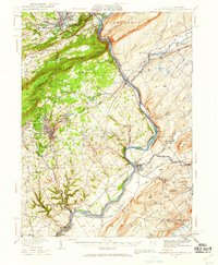
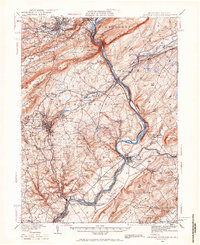
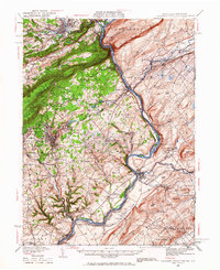
Kittatinny Mountain and the deep cut of The Gap dominate this 1930s landscape, where the Delaware River serves as a natural boundary between Pennsylvania and New Jersey. The region is a dense network of early 20th-century industry and transit, defined by the meeting of the Erie RR, D L & W RR, and L & N E RR lines. In the valley below the ridges, the twin boroughs of Stroudsburg and East Stroudsburg act as central hubs, while the slate-belt influence is visible to the south around Bangor and Pen Argyl.
Find a feature on this map
117 named features on this map. Tap any name to fly to it.
Don’t see what you’re looking for? This feature index may not catch every label — zoom into the map to look around manually.
Map Details
Editions of this 1936 Delaware Water Gap Map
4 editions found
Other maps of this area

1888 · Hackettstown
USGS Topo · 1:62,500

1890 · Easton
USGS Topo · 1:62,500

1890 · High Bridge
USGS Topo · 1:62,500

1891 · Easton
USGS Topo · 1:62,500

1891 · Wallpack
USGS Topo · 1:62,500

1891 · Delaware Water Gap
USGS Topo · 1:62,500

1893 · Delaware Water Gap
USGS Topo · 1:62,500

1893 · Wallpack
USGS Topo · 1:62,500

1894 · Hackettstown
USGS Topo · 1:62,500

1894 · Allentown
USGS Topo · 1:62,500