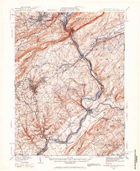
1936 Map of Delaware Water Gap
USGS Topo · Published 1966About this map
The Delaware River cuts through the ancient ridges of Blue Mountain at the iconic Water Gap, forming a natural corridor for some of the region's most important early infrastructure. This landscape is defined by its deep rail history, featuring the Delaware Lackawanna and Western RR and the Belvidere Delaware RR, which follows the river's winding course. The valley is dotted with historic settlements like Oxford Furnace and Portland, while an Emergency Landing Field near Hutchinsons and Fire Lookout Towers atop Mt Minsi and Mt Tammany indicate the transition into early 20th-century aviation and forest management.
Find a feature on this map
149 named features on this map. Tap any name to fly to it.
Don’t see what you’re looking for? This feature index may not catch every label — zoom into the map to look around manually.
Map Details
Editions of this 1936 Delaware Water Gap Map
4 editions found

Other maps of this area

1888 · Hackettstown
USGS Topo · 1:62,500

1890 · Easton
USGS Topo · 1:62,500

1890 · High Bridge
USGS Topo · 1:62,500

1891 · Easton
USGS Topo · 1:62,500

1891 · Wallpack
USGS Topo · 1:62,500

1891 · Delaware Water Gap
USGS Topo · 1:62,500

1893 · Delaware Water Gap
USGS Topo · 1:62,500

1893 · Wallpack
USGS Topo · 1:62,500

1894 · Hackettstown
USGS Topo · 1:62,500

1894 · Allentown
USGS Topo · 1:62,500