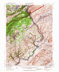
1936 Map of Delaware Water Gap
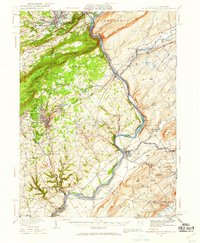
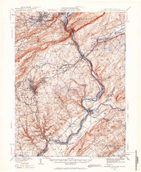
USGS Topo · Published 1966About this map
Mt Minsi and Mt Tammany frame the dramatic geological breach where the Delaware River cuts through Kittatinny Mountain. This 1930s-era survey reveals a landscape defined by sharp elevation changes and a dense concentration of transportation infrastructure along the river valley and gap. The complex rail network of the era is evident, featuring the Belvidere Delaware RR and the New York Susquehanna and Western RR, which serviced the slate-quarrying and industrial hubs of Bangor, Pen Argyl, and East Bangor.
Find a feature on this map
131 named features on this map. Tap any name to fly to it.
Don’t see what you’re looking for? This feature index may not catch every label — zoom into the map to look around manually.
Map Details
Editions of this 1936 Delaware Water Gap Map
4 editions found

Other maps of this area

1888 · Hackettstown
USGS Topo · 1:62,500

1890 · Easton
USGS Topo · 1:62,500

1890 · High Bridge
USGS Topo · 1:62,500

1891 · Easton
USGS Topo · 1:62,500

1891 · Wallpack
USGS Topo · 1:62,500

1891 · Delaware Water Gap
USGS Topo · 1:62,500

1893 · Delaware Water Gap
USGS Topo · 1:62,500

1893 · Wallpack
USGS Topo · 1:62,500

1894 · Hackettstown
USGS Topo · 1:62,500

1894 · Allentown
USGS Topo · 1:62,500