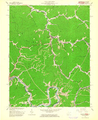
1963 Map of Delbarton
USGS Topo · Published 1964About this map
The Norfolk and Western railway snakes through the narrow valleys of Mingo County, defining the industrial and social life of this coal country during the mid-1960s. The map illustrates a dense network of mountain communities such as Delbarton, Red Jacket, and Matewan that developed along the winding Pigeon Creek and the Tug Fork river. This era shows the landscape heavily influenced by extraction, with Lando Mines and various Gas Wells appearing alongside established family landmarks. The topographic detail reveals how settlements were forced into the hollows, often centered around local spiritual and ancestral sites like the Elk Creek Community Ch, Varney Cem, and Phillips Cem. From the high vantage point of Buffalo Mtn and its Lookout Tower, the map captures the transition from high-ridgeline wilderness to the bustling rail corridors that connected these West Virginia and Kentucky border towns.
Find a feature on this map
71 named features on this map. Tap any name to fly to it.
Don’t see what you’re looking for? This feature index may not catch every label — zoom into the map to look around manually.
Map Details
Editions of this 1963 Delbarton Map
3 editions found
Other maps of this area

1887 · Warfield
USGS Topo · 1:125,000

1891 · Warfield
USGS Topo · 1:125,000

1909 · Matewan
USGS Topo · 1:48,000

1910 · Holden
USGS Topo · 1:48,000

1910 · Naugatuck
USGS Topo · 1:48,000

1912 · Naugatuck
USGS Topo · 1:62,500

1912 · Holden
USGS Topo · 1:62,500

1915 · Williamson
USGS Topo · 1:48,000

1915 · Naugatuck
USGS Topo · 1:48,000

1915 · Matewan
USGS Topo · 1:48,000