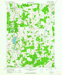
1963 Map of Delevan
USGS Topo · Published 1964About this map
Delevan and Machias serve as the primary hubs in this Western New York landscape, where the confluence of rail lines and creek valleys shaped the local development. The Pennsylvania Railroad and the Baltimore and Ohio Railroad intersect at Machias Junction, highlighting the era's reliance on rail transport for moving timber and agricultural goods through the Ischua Valley. Near the water, Lime Lake is a prominent feature, flanked by the County Infirmary and several residential roads.
Find a feature on this map
75 named features on this map. Tap any name to fly to it.
Don’t see what you’re looking for? This feature index may not catch every label — zoom into the map to look around manually.
Map Details
Editions of this 1963 Delevan Map
3 editions found
Other maps of this area

1923 · Arcade
USGS Topo · 1:62,500

1924 · Ellicottville
USGS Topo · 1:62,500

1924 · Franklinville
USGS Topo · 1:62,500

1925 · Springville
USGS Topo · 1:62,500

1925 · Arcade
USGS Topo · 1:62,500

1941 · Ellicottville
USGS Topo · 1:62,500

1942 · Franklinville
USGS Topo · 1:62,500

1957 · Sardinia
USGS Topo · 1:24,000

1960 · Buffalo
USGS Topo · 1:250,000

1962 · Buffalo
USGS Topo · 1:250,000