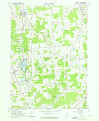
1963 Map of Delevan
USGS Topo · Published 1976About this map
Lime Lake serves as a central geographic anchor for this pocket of Western New York, where the Pennsylvania Railroad tracks run north-south through the village of Delevan. The landscape is a patchwork of small hamlets and dairy-era agricultural infrastructure, with Elton, Machias, and Sandusky connected by a network of family-named roads like California Road and Weaver Road. Notable for local historians is the site of the County Infirmary south of the lake, along with several rural burial grounds including Maplehurst Cem and Siloam Cem.
Find a feature on this map
78 named features on this map. Tap any name to fly to it.
Don’t see what you’re looking for? This feature index may not catch every label — zoom into the map to look around manually.
Map Details
Editions of this 1963 Delevan Map
3 editions found
Other maps of this area

1923 · Arcade
USGS Topo · 1:62,500

1924 · Ellicottville
USGS Topo · 1:62,500

1924 · Franklinville
USGS Topo · 1:62,500

1925 · Springville
USGS Topo · 1:62,500

1925 · Arcade
USGS Topo · 1:62,500

1941 · Ellicottville
USGS Topo · 1:62,500

1942 · Franklinville
USGS Topo · 1:62,500

1957 · Sardinia
USGS Topo · 1:24,000

1960 · Buffalo
USGS Topo · 1:250,000

1962 · Buffalo
USGS Topo · 1:250,000