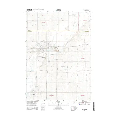
2015 Map of Dell Rapids
USGS Topo · Published 2015About this map
Dell Rapids sits along the winding course of the Big Sioux River, a landscape defined by the distinct quartzite formations known as the Dells of the Sioux River. This 2015 survey captures the city's grid-like development north of the river, while the southern reach includes Dells Island and the rural outskirts leading toward Baltic. The topography transitions across the Coteau des Prairies, a high plateau that influences the drainage patterns of Silver Cr and Slip-up Cr. Genealogy researchers will find several local burial grounds clearly marked, including Dell Rapids Cem, Stordahl Cem, and Saint Olaf Cem, which are scattered throughout the agricultural sections of the county line. The presence of Weelborg Airport and a network of numbered section roads, such as Jasper St and 250th St, illustrate the modern infrastructure supporting the farming communities of eastern South Dakota.
Find a feature on this map
66 named features on this map. Tap any name to fly to it.
Don’t see what you’re looking for? This feature index may not catch every label — zoom into the map to look around manually.
Map Details
Editions of this 2015 Dell Rapids Map
This is the sole edition of this map. No revisions or reprints were ever made.
Other maps of this area

1955 · Sioux Falls
USGS Topo · 1:250,000

1958 · Sioux Falls
USGS Topo · 1:250,000

1962 · Colton SE
USGS Topo · 1:24,000

1962 · Dell Rapids
USGS Topo · 1:24,000

1962 · Renner
USGS Topo · 1:24,000

1962 · Garretson West
USGS Topo · 1:24,000

1962 · Crooks
USGS Topo · 1:24,000

1963 · Trent
USGS Topo · 1:24,000

1963 · Colman
USGS Topo · 1:24,000
1972 · Dell Rapids NE
USGS Topo · 1:24,000