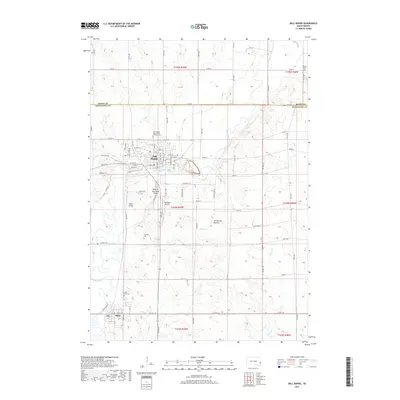
2017 Map of Dell Rapids
USGS Topo · Published 2017About this map
The Big Sioux River carves a striking path through the landscape of northern Minnehaha County, defining the character of Dell Rapids and the southern settlement of Baltic. This survey documents the unique topography where the river encounters the Coteau des Prairies, creating the distinctive geological formations of the Dells of the Sioux River and Dells Island. The map provides a detailed view of the regional settlement pattern, anchored by numerous small community burial grounds such as Stordahl Cem, Saint Olaf Cem, and the Dell Rapids Saint Mary's Catholic Cem. These sites, along with the Nelson Cem to the northeast, serve as vital touchstones for family history. The grid-based agricultural landscape is interspersed with infrastructure like the Weelborg Airport and several creeks, including Silver Cr and Slip-up Cr, which drain the prairie toward the primary river valley.
Find a feature on this map
55 named features on this map. Tap any name to fly to it.
Don’t see what you’re looking for? This feature index may not catch every label — zoom into the map to look around manually.
Map Details
Editions of this 2017 Dell Rapids Map
This is the sole edition of this map. No revisions or reprints were ever made.
Other maps of this area

1955 · Sioux Falls
USGS Topo · 1:250,000

1958 · Sioux Falls
USGS Topo · 1:250,000

1962 · Colton SE
USGS Topo · 1:24,000

1962 · Dell Rapids
USGS Topo · 1:24,000

1962 · Renner
USGS Topo · 1:24,000

1962 · Garretson West
USGS Topo · 1:24,000

1962 · Crooks
USGS Topo · 1:24,000

1963 · Trent
USGS Topo · 1:24,000

1963 · Colman
USGS Topo · 1:24,000
1972 · Dell Rapids NE
USGS Topo · 1:24,000