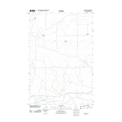
2011 Map of Delphia
USGS Topo · Published 2011About this map
The Musselshell River winds through the southern edge of this Montana landscape, where the small settlement of Delphia stands as a focal point for the surrounding ranchlands. The area's water management is evident through a series of specialized reservoirs including the WB Goffena Number 1 Dam, Jamgo Number 1 Dam, and Montana Number 32 Dam, which support agricultural life in this arid region. North of the river, the terrain is defined by the drainage patterns of Sand Creek and Fourmile Creek. A network of rural routes, such as Big Wall Rd and Teton Rd, connects remote landmarks like Akers Ranch to the river corridor. The presence of named trails like Painted Horse Trl and Jackrabbit Ln suggests a modern rural residential character layered over traditional Musselshell County grazing lands.
Find a feature on this map
20 named features on this map. Tap any name to fly to it.
Don’t see what you’re looking for? This feature index may not catch every label — zoom into the map to look around manually.
Map Details
Editions of this 2011 Delphia Map
This is the sole edition of this map. No revisions or reprints were ever made.
Other maps of this area

1954 · Roundup
USGS Topo · 1:250,000

1958 · Roundup
USGS Topo · 1:250,000

1963 · Musselshell
USGS Topo · 1:24,000
1963 · Akers Ranch
USGS Topo · 1:24,000

1963 · Musselshell NW
USGS Topo · 1:24,000

1963 · Delphia
USGS Topo · 1:24,000

1979 · Roundup
USGS Topo · 1:100,000

1979 · Corey Flat
USGS Topo · 1:24,000

1979 · Gage NE
USGS Topo · 1:24,000

1979 · Chimney Butte
USGS Topo · 1:24,000