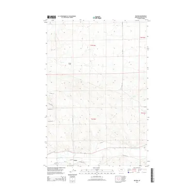
2014 Map of Delphia
USGS Topo · Published 2014About this map
The Musselshell River meanders across the southern portion of this landscape, defining the primary watercourse for the Delphia area. The settlement itself is positioned north of the river, where local transport routes like Delphia Rd and W Musselshell Rd converge. This map illustrates a transition from the river bottomlands to the coulee-carved uplands to the north, characterized by features such as McLean Coulee and the drainage of Sand Cr.
Find a feature on this map
22 named features on this map. Tap any name to fly to it.
Don’t see what you’re looking for? This feature index may not catch every label — zoom into the map to look around manually.
Map Details
Editions of this 2014 Delphia Map
This is the sole edition of this map. No revisions or reprints were ever made.
Other maps of this area

1954 · Roundup
USGS Topo · 1:250,000

1958 · Roundup
USGS Topo · 1:250,000

1963 · Musselshell
USGS Topo · 1:24,000
1963 · Akers Ranch
USGS Topo · 1:24,000

1963 · Musselshell NW
USGS Topo · 1:24,000

1963 · Delphia
USGS Topo · 1:24,000

1979 · Roundup
USGS Topo · 1:100,000

1979 · Corey Flat
USGS Topo · 1:24,000

1979 · Gage NE
USGS Topo · 1:24,000

1979 · Chimney Butte
USGS Topo · 1:24,000