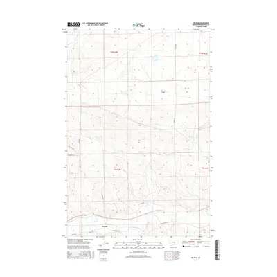
2017 Map of Delphia
USGS Topo · Published 2017About this map
Delphia lies at the southern edge of this landscape, situated where the Musselshell River meanders through the valley. The geography is defined by a network of drainage systems and coulees, including McLean Coulee and Fourmile Cr, which shape the transition from the river bottom to the higher plains. Local transport is marked by a series of descriptive routes such as Sheepherder Trl and Painted Horse Trl, reflecting the ranching and livestock heritage of Musselshell County. The presence of Fourmile Springs and various creek beds like N Willow Cr and Sand Cr indicates the critical importance of water sources in this environment. Farther from the river, the terrain rises into sectioned land demarcated by Teton Rd and N Delphia Rd, providing a clear view of the area's rural road development.
Find a feature on this map
20 named features on this map. Tap any name to fly to it.
Don’t see what you’re looking for? This feature index may not catch every label — zoom into the map to look around manually.
Map Details
Editions of this 2017 Delphia Map
This is the sole edition of this map. No revisions or reprints were ever made.
Other maps of this area

1954 · Roundup
USGS Topo · 1:250,000

1958 · Roundup
USGS Topo · 1:250,000

1963 · Musselshell
USGS Topo · 1:24,000
1963 · Akers Ranch
USGS Topo · 1:24,000

1963 · Musselshell NW
USGS Topo · 1:24,000

1963 · Delphia
USGS Topo · 1:24,000

1979 · Roundup
USGS Topo · 1:100,000

1979 · Corey Flat
USGS Topo · 1:24,000

1979 · Gage NE
USGS Topo · 1:24,000

1979 · Chimney Butte
USGS Topo · 1:24,000