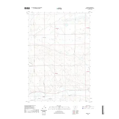
2020 Map of Delphia
USGS Topo · Published 2020About this map
The Musselshell River corridor anchors the southern reach of this landscape, where the small settlement of Delphia sits near the junction of several rural routes including Delphia Rd and Goffena Rd. This area of Musselshell County is defined by a series of drainages and coulees that cut through the high plains, including the prominent McLean Coulee and Sand Cr. The presence of Fourmile Springs and various creek beds like Fattig Cr and N Willow Cr illustrates the vital role of water sources in this cattle-ranching region. Further north, the terrain becomes increasingly complex with named trails such as the Sheepherder Trl and Painted Horse Trl winding through the draws, reflecting a land use pattern deeply tied to livestock movement and the open range.
Find a feature on this map
21 named features on this map. Tap any name to fly to it.
Don’t see what you’re looking for? This feature index may not catch every label — zoom into the map to look around manually.
Map Details
Editions of this 2020 Delphia Map
This is the sole edition of this map. No revisions or reprints were ever made.
Other maps of this area

1954 · Roundup
USGS Topo · 1:250,000

1958 · Roundup
USGS Topo · 1:250,000

1963 · Musselshell
USGS Topo · 1:24,000
1963 · Akers Ranch
USGS Topo · 1:24,000

1963 · Musselshell NW
USGS Topo · 1:24,000

1963 · Delphia
USGS Topo · 1:24,000

1979 · Roundup
USGS Topo · 1:100,000

1979 · Corey Flat
USGS Topo · 1:24,000

1979 · Gage NE
USGS Topo · 1:24,000

1979 · Chimney Butte
USGS Topo · 1:24,000